
On October 28, 2026, a New York appeals court held that a "dotted line" on a Big Apple map did not give New York City written notice of a hole in a Queens crosswalk (see our Decision Day entry on Melendez v City of New York). Many New Yorkers have never heard of a Big Apple map. For more than 20 years, these maps could decide a case against the City over a broken sidewalk or a pothole, and in some cases they still can. "When you had a map, you had a very good case," one lawyer told a Queens newspaper in 2008 (QNS).
The Pothole Law
For more than 40 years, New York City has had a prior written notice law, which courts have called the Pothole Law. It says that "[n]o civil action shall be maintained against the city" for an injury caused by a defective "street, highway, bridge, wharf, culvert, sidewalk or crosswalk" unless "written notice of the defective, unsafe, dangerous or obstructed condition, was actually given to the commissioner of transportation" or to someone the commissioner has authorized to receive it, and the City then failed to fix it within 15 days. The law also counts written notice of an earlier injury from the same condition, and the City's own written acknowledgment of it (Administrative Code § 7-201(c)(2)).
As the Court of Appeals has explained, the law limits the City's duty "by imposing liability only for those defects or hazardous conditions which its officials have been actually notified exist at a specified location" (Katz v City of New York, 87 NY2d 241, 243 [1995]). The commissioner of transportation must keep an indexed record of the written notices the City receives, and "[t]his record shall be a public record" (Administrative Code § 7-201(c)(3)).
The Trial Lawyers' Answer: Mapping the City
If the City had to be told in writing, someone had to do the telling. "Big Apple is a corporation established by the New York State Trial Lawyers Association for the purpose of giving notices in compliance with the Pothole Law," the Court of Appeals has explained. "It does so through maps on which coded symbols are entered to represent defects" (D'Onofrio v City of New York, 11 NY3d 581, 584 [2008]). Big Apple hired a mapping company to go around the City and record defective sidewalks and potholes, and it delivered the maps to the Department of Transportation (QNS).
Whether the maps counted went to court in the early 1980s, and the courts held that they did. As the Court of Appeals later summarized, maps "prepared by Big Apple Pothole and Sidewalk Protection Committee, Inc. and filed with the Department of Transportation serve as prior written notice of defective conditions depicted thereon" (Katz, citing Big Apple Pothole & Sidewalk Protection Comm. v Ameruso, 110 Misc 2d 688, affd 86 AD2d 986, lv denied 56 NY2d 507). Court decisions have called the group both a "Committee" and a "Corporation."
What a Big Apple Map Key Looks Like
Each map came with a key that explained its symbols. Here is an example:
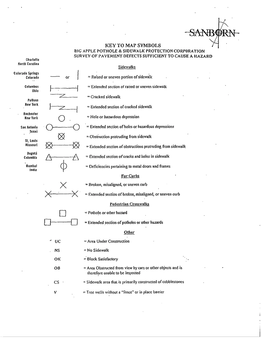
On this key, a straight line means a "[r]aised or uneven portion of sidewalk," a circle means a "[h]ole or hazardous depression," and, for curbs, an X means a "[b]roken, misaligned, or uneven curb." In a pedestrian crosswalk, a square means a "[p]othole or other hazard." Symbols joined by a line mark an extended section of a defect, and letter codes cover other conditions, such as "OK" for "Block Satisfactory." There is no dotted line on this key.
The Map Has to Match the Defect
A map counts only for what it actually shows. In 2008, the Court of Appeals decided two Big Apple map cases together. In the first, the map showed the straight-line symbol for a raised or uneven sidewalk, but there was no evidence that a raised or uneven sidewalk caused the man's fall; he testified that his feet were caught at a grating. In the second, a woman tripped over an elevation in the sidewalk, but the symbol she relied on was a line with a diamond at one end and, at the other, a mark that had been "variously described as a poorly drawn X, the Hebrew letter shin, or a pitchfork without the handle." The court noted that "[n]o symbol resembling this appears in the legend to the map," and held that "we do not see how a rational jury could find that this mark conveyed any information at all" (D'Onofrio, 11 NY3d at 585). Both claims against the City failed. Two judges disagreed, writing that "[m]apping hazards is hardly an exact science" (id. at 586).
The same rule decided Melendez. The "dotted line" on the maps "did not correspond to any symbol denoting a defect as listed in the 'Key to Map Symbols' for the maps," so the City had no prior written notice, and the dismissal of the case was affirmed.
When the facts are genuinely disputed, a jury may decide. In a 2020 case, a woman fell on a stretch of Brooklyn sidewalk that a Big Apple map marked "OK," but the same map also showed the symbol for a "[r]aised or uneven portion of sidewalk" in that area. The appeals court held that whether her defect "was the same as the 'raised or uneven portion of sidewalk' indicated on the Big Apple map, of which the City may have received prior notice, was an issue of fact for the jury's resolution" (Harrison v City of New York, 184 AD3d 742 [2d Dept 2020]).
2003: Sidewalks Shift to Property Owners, and the Maps Stop
In 2003, the City Council changed who answers for most sidewalks. Local Law No. 49 of 2003 was signed on July 16, 2003 and took effect on September 14, 2003 (Gangemi v City of New York, 13 Misc 3d 1112 [Sup Ct, Kings County 2006]). That local law added Administrative Code § 7-210, which, with some exceptions, makes the abutting owner, meaning the owner of the building or lot that the sidewalk runs in front of, liable for injuries caused by failing to keep the sidewalk reasonably safe (Administrative Code § 7-210). The Court of Appeals has explained that the Council acted "in an effort to transfer tort liability from the City to adjoining property owners as a cost-saving measure" (Vucetovic v Epsom Downs, Inc., 10 NY3d 517, 521 [2008]).
With those sidewalk claims now against private owners, who are not protected by the City's prior written notice law, the maps lost much of their purpose. According to QNS, "Big Apple continued sending maps until 2003, when the new sidewalk law was passed." Maps from around that time still turn up in court: in Harrison, the maps had been served on the Department of Transportation on February 2, 2004.
Why Old Maps Still Matter: Some Exceptions
The City is still responsible, subject to its prior written notice law, for its streets and crosswalks, for sidewalks in front of City property, and for sidewalks in front of "one-, two- or three-family residential real property that is (i) in whole or in part, owner occupied, and (ii) used exclusively for residential purposes" (Administrative Code § 7-210(c)). In those cases, a Big Apple map can still be the written notice. Our post on falls on wet leaves explains who is responsible for which sidewalks.
And a map does not simply expire. The Court of Appeals has held that notice must be "traced to the most current Big Apple map on file, i.e., the map that is the closest in time to the date a defect is alleged to have caused an accident" (Katz, 87 NY2d at 244-245, as quoted in Weissman, below). With new maps no longer coming in, the most current map for a block may now be more than 20 years old. A Queens trial court rejected the City's argument that a five-year-old map was too old to count: "In the absence of a clear provision in section 7-201 (c) (2) of the Administrative Code setting forth an expiration date for prior written notices, the court may not impose one by judicial fiat" (Weissman v City of New York, 29 Misc 3d 1064, 1070 [Sup Ct, Queens County 2010]). In Harrison, maps served more than 10 years before the fall were enough to send the notice question to a jury.
In our experience, some of the defects marked on maps filed more than 20 years ago are still there today, never repaired.
What to Do After a Fall on a City Street, Crosswalk, or Sidewalk
- Get medical care, and follow your doctor's advice.
- If your medical condition allows, photograph the exact defect from several angles, close up and from a distance, with something in the picture that shows its size, before it is repaired. Because a map's symbol has to match the defect, a clear photograph of what you actually tripped on matters.
- Write down the exact location: the address, the nearest corner, and which side of the street.
- Write down the names and phone numbers of anyone who saw the fall.
- Talk to a lawyer early. A claim against the City generally requires a sworn Notice of Claim served within 90 days (General Municipal Law § 50-e), and the lawsuit generally must be started within one year and 90 days (General Municipal Law § 50-i). A lawyer can request the City's records for the exact location, including any Big Apple maps. In some circumstances, your time to act may be even shorter.
Our Decision Day entries on Young v City of New York and Maldonado v City of New York show how the City must prove its records search. If you were hurt in a fall on a City street, crosswalk, or sidewalk, contact The Eskesen Law Firm for a free consultation. Calls are answered live 24 hours a day, 7 days a week.
Questions about your own accident?
Call us for a free consultation. Calls answered live 24 hours a day, 7 days a week.